
The Best Fall Hikes in Washington State
I think fall is my absolute favorite season! The crisp air, vibrant and colorful trails, and magical yellow larch trees - there's truly nothing like it! Every year, the lush alpine meadows turn radiant hues of reds, yellows, and oranges and truly is one of the most spectacular sights to see. In this blog, I'm sharing with you some of my favorite trails to explore and hike this season! I cannot wait to keep exploring this beautiful state and finding more trails to share with you all - especially during my favorite season, the fall! Always remember to leave no trace, pack out what you pack in, stay on designated trails and leave the trails even better than you found them to keep Washington wild and beautiful for generations to come.
Happy Trails,
Lauren
Disclaimer: This blog post features affiliate links. This means I get a small commission if you make a purchase at no extra cost to you! Thank you so much for your support!
Fall Playlist
Fall Favorites
Gear up for the trails or cozy up at home with some of my fall favorites!

Best Time of Year for Fall Colors
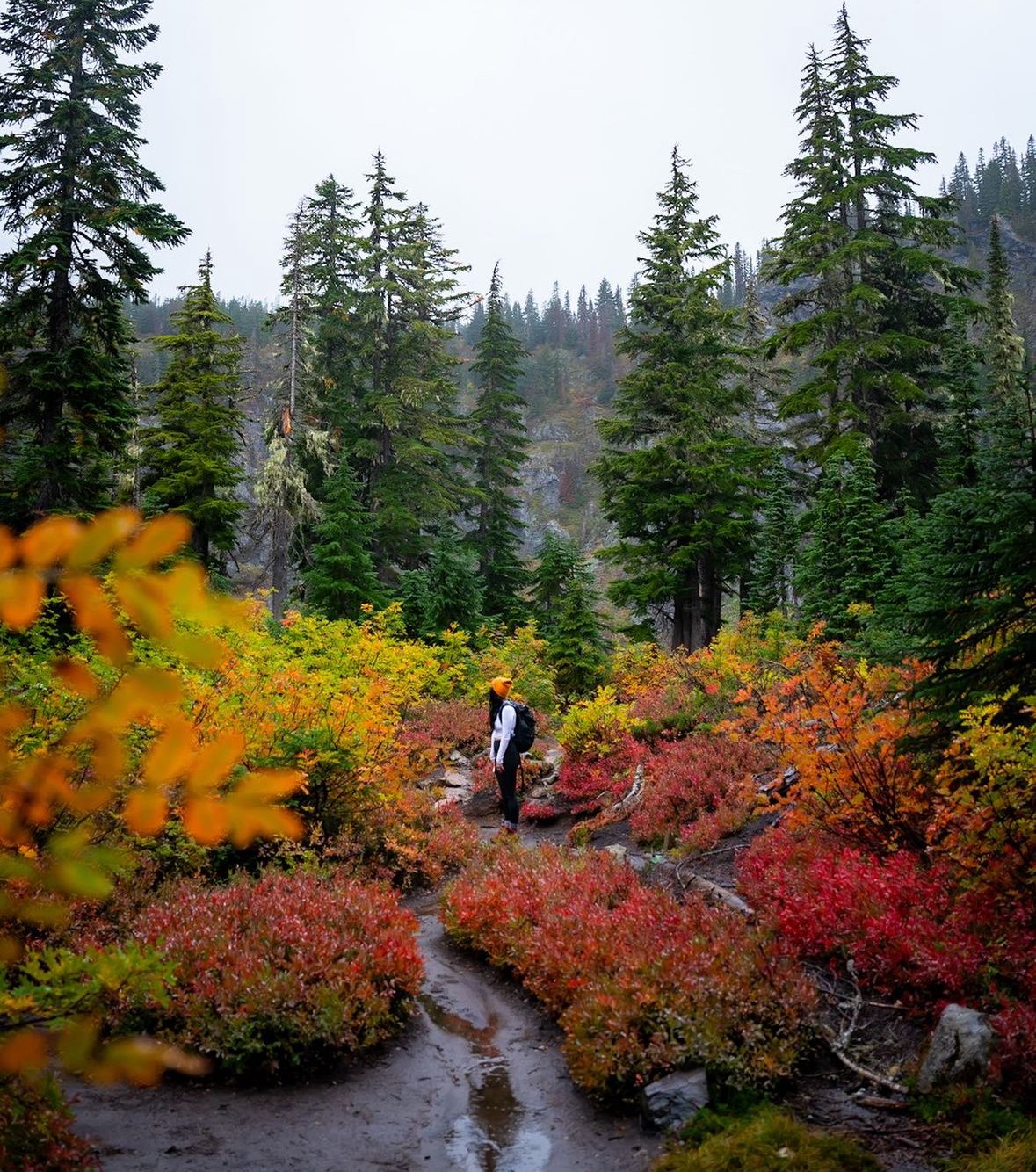
Fall is undoubtedly the most enchanting time of year to discover the vibrant colors of Washington. From late September to the end of October, nature unveils its awe-inspiring spectacle of autumn foliage, reaching its peak in mid-October. Before heading out on the trails, it's always wise to review WTA trail reports or AllTrails to ensure trail accessibility and to stay informed about any potential hazards such as washouts or icy/snowy conditions. Remember, the weather in the Pacific Northwest during fall can be unpredictable, so don't forget to check the forecast before setting off on your adventure. Don't forget to bring along warm layers, a cozy hat, snug gloves, and anything else that will keep you comfortable, warm, and dry during your hike. And hey, why not bring some hot cocoa and a trusty Jetboil to add an extra touch of coziness to your outdoor experience? Get ready for a season filled with unforgettable memories and the most breathtaking colors.

What is a Larch and Where to Find Them
Do you ever hear people raving about the Larches in Washington and think....what exactly is a Larch? A Larch is a deciduous tree disguised to look like a pine tree. In the summer, they are harder to spot since they blend in with all the other green fir trees. But in the fall - their needles turn from green to a vibrant yellow just like all the other deciduous trees! Their miraculous display of yellow only lasts for a few weeks - so be sure to catch them at their prime (we do this by closely monitoring trail reports since every year the larches are at their peak at different times of October). Last year, we saw yellow larches earlier towards the end of September!
In Washington State, larches are generally found on the east slopes of the Cascade Crest north of Snoqualmie Pass and above 3000 feet of elevation, going up to around 7000 feet of elevation. Most of the Larches we have seen have all been at either North Cascades National Park or The Enchantments. They truly are a magical sight to see, and if you get the chance to travel to Washington or explore here in the fall - they are a must-see!

Research / Navigation
I recommend downloading the Alltrails app - this is the best app in my opinion for finding trails that are suitable for backpacking. You can filter out the trails you are searching through with the keywords like "Wildflowers," "Forest," and "Lake" for example so you can find your very perfect summer trail! Also, we love using Washington Trails Association Trip Reports (if you're planning on hiking/backpacking in Washington, where we are based out of) is another great place to research trails. Both Alltrails and WTA Trip Reports have been amazing resources for us to find accessible trails that are suitable for backpacking! People also provide great reviews of the trail as well so you know what you’re getting into (so it’s not too hard, or not accessible - downed tree, closed trailhead, washout, etc). The very best time to hike in Washington is late June to mid October. But always be sure to check trail reports before visiting!
Alltrails also comes in handy for having navigation right on your cell phone - you can download the trail before you go so you have the map downloaded on your phone and it will automatically track you on the app so you know where you are on the trail and so you don’t make any wrong turns. My favorite feature on this app is that it also has icons that shows you where camping spots are and where restrooms are along the trails so that you can navigate to your desired location with ease. And to be sure you are camping in a designated camping area.
Passes for hiking trails in Washington
To hike most of the trails in Washington you need a Discover Pass, Northwest Forest Pass, or America the Beautiful Pass (or can pay the entry fee to the national park). Check Alltrails to see if the trail you are going to require one of these passes.
Map
Leave No Trace
Before you explore these beautiful places, I want to emphasize the importance of Leave No Trace. I share these places and trails with you trusting that you will be respectful and leave them even better than you found them so we can keep them beautiful for future generations to come. Please read this guide below on how to adhere to this principle and leave the places we love most wild and beautiful:
Plan Ahead and Prepare:
Research the area you'll be visiting, familiarizing yourself with any regulations or restrictions.Pack appropriately for the terrain and weather conditions to minimize waste and unnecessary impact.
Travel and Camp on Durable Surfaces:
Stick to established trails and campsites to avoid damaging fragile vegetation and ecosystems. When camping, choose durable surfaces such as rock, gravel, or dry grass to minimize your impact on the environment.
Dispose of Waste Properly:
Pack out all trash, including food wrappers, toiletries, and any other waste you generate. Practice proper human waste disposal by digging a cat hole at least 6-8 inches deep and 200 feet away from water sources, trails, and campsites.
Leave What You Find:
Resist the temptation to take home souvenirs or disturb natural features such as rocks, plants, or wildlife. Leave natural objects and cultural artifacts as you found them for others to enjoy.
Minimize Campfire Impacts:
Follow local regulations regarding campfires, including any fire bans or restrictions. Use existing fire rings if available and keep fires small. Ensure fires are fully extinguished before leaving.
Respect Wildlife:
Observe wildlife from a distance and avoid approaching or feeding them. Keep pets under control and leashed where required to prevent them from disturbing wildlife or damaging habitats.
Be Considerate of Other Visitors:
Respect the peace and solitude of others by keeping noise levels to a minimum. Yield to other hikers and share the trail courteously, stepping aside to let faster hikers pass.
Educate Others:
Lead by example and share Leave No Trace principles with fellow outdoor enthusiasts. Encourage responsible behavior and stewardship of our natural spaces to ensure their preservation for generations to come.
By following these guidelines and adopting Leave No Trace practices, you can help minimize your impact on the environment and contribute to the conservation of our precious outdoor resources. To learn more, head over to Leave No Trace Center for Outdoor Ethics website.
Skyline Loop

Location: Mount Rainier National Park
Distance: 6.2 miles
Elevation Gain: 1,788 feet
Difficulty: Hard
Pass: America the Beautiful Pass or Pay entry fee
Drive from Seattle: 2 hours and 30 minutes
Dog Friendly: No
Experience this beautiful and breathtaking hike at Mount Rainier National Park – this is one of our absolute favorite trails in the summer AND in the fall. It’s 6.2-mile loop trail near Paradise Inn, Washington. Be sure to go to the Myrtle Falls Viewpoint first to see the iconic waterfall with Mount Rainier behind it. So epic and beautiful! We always try to get to this trail early for sunrise or for sunset to avoid crowds. The fall colors here are absolutely stunning and must be added to your fall hiking list this season!


Cutthroat Pass

Location: North Cascades National Park
Distance: 10 miles
Elevation Gain: 2,024 feet
Difficulty: Hard
Pass: America the Beautiful Pass
Drive from Seattle: 3 hours and 15 minutes
Dog Friendly: Yes
One of the most beautiful hikes for fall colors and yellow larch trees. Hike up a gradual grade through a beautiful forest, cascading mountain peaks and arrive to a sea of vibrant yellow larch trees.


Spray Park Trail to Mount Pleasant

Location: Mount Rainier National Park
Distance: 6.9 miles
Elevation Gain: 2,198 feet
Difficulty: Moderate to Hard
Pass: America the Beautiful Pass
Drive from Seattle: 2 hours and 30 minutes
Dog Friendly: No
A stunning hike for fall colors here in Washington with breathtaking views of Rainier, vibrant fall colored meadows, and if you're lucky you might see a black bear munching on wild berries. I recommend a high clearance vehicle to get to the trailhead.


Rachel & Rampart Lakes Trail

Location: Cle Elum, Washington
Distance: 8 miles
Elevation Gain: 1600 feet
Difficulty: Hard
Pass: Northwest Forest Pass
Drive from Seattle: 1 hour and 15 minutes
Dog Friendly: Yes
Rachel Lake Trail is a scenic and moderately challenging hike located in the Alpine Lakes Wilderness in Washington State. The trail spans approximately 8 miles round trip and gains around 1,600 feet in elevation, making it a popular choice for those seeking a mix of forested paths and alpine beauty.

Lake Ingalls

Location: Cle Elum, Washington
Distance: 8.9 miles
Elevation Gain: 2,834 feet
Difficulty: Hard
Pass: Northwest Forest Pass
Drive from Seattle: 2 hours and 20 minutes
Dog Friendly: Yes
Lake Ingalls Trail in the fall is a stunning adventure in Washington's Alpine Lakes Wilderness, offering hikers dramatic alpine scenery, vibrant fall colors, and sweeping views of rugged peaks.
Summit Lake Trail

Location: Carbonado, Washington
Distance: 5.7 miles
Elevation Gain: 1,443 feet
Difficulty: Moderate
Pass: Northwest Forest Pass
Drive from Seattle: 2 hours and 30 minutes
Dog Friendly: Yes
We love Summit Lake Trail so much since it is as close you can get to Mount Rainier National Park without being inside the national park which means we can bring our dog! Hike up to a beautiful blue lake and on a clear day – be able to see Mount Rainier behind the lake. The most picturesque scene. Keep hiking from the lake until you reach the summit to get the most epic view of Rainier! Be sure you have a high clearance / AWD vehicle to get to this trailhead. The road up to the trail is very vertical, and has lots of rocks and potholes. So just be sure to drive slowly and you should be ok. Also – when you map to this trailhead on Apple Maps will tell you it is going to take 4-5 hours to reach the trailhead. Which is not true – it only does this since it knows you have to go up a pot hole filled road to reach the trailhead so it adds some extra time on the GPS. But it truly only takes about 2 1/2 hours from Seattle to reach this trail!
Lake Ann Trail

Location: Carbonado, Washington
Distance: 8.6. miles
Elevation Gain: 2,047 feet
Difficulty: Hard
Pass: Northwest Forest Pass
Drive from Seattle: 2 hours and 40 minutes
Dog Friendly: Yes
The Lake Ann Trail, located near Deming, Washington, transforms into a breathtaking wonder during the fall. Nestled within the North Cascades, this trail offers a 7.7-mile round trip hike with dramatic views of Mount Shuksan and its glaciers. As fall settles in, the landscape becomes a vibrant tapestry of autumn colors as well as wild huckleberries all along the trail.
Blue Lake Trail
Location: North Cascades National Park
Distance: 4.6 miles
Elevation Gain: 921 feet
Difficulty: Moderate
Pass: America the Beautiful Pass or Pay entry fee
Drive from Seattle: 3 hours and 10 minutes
Dog Friendly: No
A short and easier hike to find beautiful yellow larch trees in the North Cascades up to a pristine blue lake. Don't forget to check out the tarn a short hike up above the lake for more larch trees and beautiful views! Everyone seems to stop at the lake and miss out on the beautiful hidden tarn.

Bagley Lakes Loop
Location: Mount Baker National Forest
Distance: 2.2 miles
Elevation Gain: 259 feet
Difficulty: Easy
Pass: Northwest Forest Pass
Drive from Seattle: 3 hours and 10 minutes
Dog Friendly: Yes

Goat Peak Lookout Trail

Location: Okanogan-Wenatchee National Forest
Distance: 3.3 miles
Elevation Gain: 1,443 feet
Difficulty: Hard
Pass: America the Beautiful Pass or Pay entry fee
Drive from Seattle: 4 hours 25 minutes
Dog Friendly: Yes

Park Butte Lookout Trail

Location: Mount Baker Snoqualmie National Forest
Distance: 7.2 miles
Elevation Gain: 2,220 feet
Difficulty: Moderate
Pass: Northwest Forest Pass
Drive from Seattle: 2 hours 30 minutes
Dog Friendly: Yes

Sheep Lake and Sourdough Gap Trail

Location: Okanogan-Wenatchee National Forest
Distance: 6 miles
Elevation Gain: 1,236 feet
Difficulty: Moderate
Pass: Northwest Forest Pass
Drive from Seattle: 2 hours 20 minutes
Dog Friendly: Yes

Big Four Ice Caves

Location: Mount Baker Snoqualmie National Forest
Distance: .6 miles
Elevation Gain: 29 feet (very easy, flat trail)!
Difficulty: Easy
Pass: Northwest Forest Pass
Drive from Seattle: 1 hour 20 minutes
Dog Friendly: Yes

Dock Butte Trail

Location: Okanogan-Wenatchee National Forest
Distance: 3.8 miles
Elevation Gain: 1,289 feet
Difficulty: Moderate
Pass: Northwest Forest Pass
Drive from Seattle: 2 hours 20 minutes
Dog Friendly: Yes
A beautiful trail for fall colors. Be sure to check Alltrails, this trail has been not accessible for a couple years due to a washout on the road. Hoping it opens again soon! Fun fact, the photo above made it on the cover of Washington Trails Magazine a few years ago.

The Enchantments
Location: Leavenworth
Distance: 20.5 miles
Elevation Gain: 4,954 feet
Difficulty: Hard
Pass: Northwest Forest Pass for day-use
Drive from Seattle: 2 hours 40 minutes
Dog Friendly: No
A great place to find larches, but very difficult to day hike.*Permits are required to camp overnight here through a lottery system that opens every February. Some people do day hike this - but it is a very difficult trail to day hike! Definitely recommend trying to win permits to spend more time in the beautiful place. For more information visit https://www.recreation.gov/permits/233273

